The first sign wasn’t on a satellite image, but on a quiet street corner at 6 a.m. A delivery driver in Minneapolis scraped a thin, stubborn crust of ice from his windshield and muttered that the weather felt “wrong” for late January. The air was too still, too heavy, like the city was holding its breath.
Across the country, small clues are stacking up like that. Strange temperature swings, snow turning to rain overnight, then refreezing into treacherous glaze. Meteorologists are staring at their models, refreshing charts that shift a little colder, a little more dramatic, every 12 hours.

An early February Arctic breakdown — a sharp, sudden spill of polar air — is no longer just a distant scenario on a weather geek’s forum. It’s creeping into the mainstream forecast.

And the story those maps are telling is getting harder to ignore.

What an “Arctic breakdown” really means for your street, not just the map
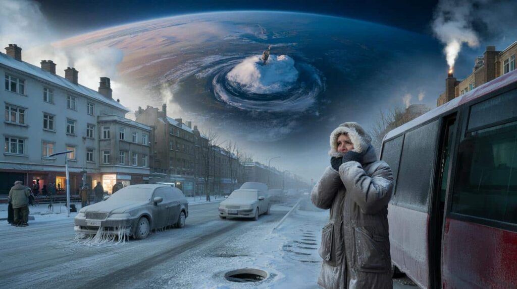
In forecasting rooms from Washington to Berlin, forecasters are seeing the same pattern: the polar vortex, that icy whirl of air high above the Arctic, wobbling and weakening. When that happens, cold air that usually stays locked far to the north can surge south like an open freezer door.
On a map, it’s just a mass of dark blue shading dripping into the mid-latitudes. On the ground, it’s the difference between a chilly morning and frozen pipes, canceled buses, and a grocery store that suddenly looks like a snowstorm movie scene.
This time, the signals are stacking up in early February. That’s late enough that people feel “done” with deep winter, and early enough that real, biting Arctic blasts are still very much on the table.
Meteorologists point to a cluster of recent model runs focusing on the first and second weeks of February. The European Centre model, the American GFS, and several ensemble systems are starting to agree: a chunk of stratospheric warming and pressure changes over the Arctic could unlock a southward plunge of polar air.
In practical terms, that means the risk zone stretches from the northern Plains and Midwest across to the Northeast in North America, and from Scandinavia into central and eastern Europe on the other side of the Atlantic. Some runs show a classic pattern: milder air surging up the West Coast while the central and eastern parts go into the deep freeze.
None of this is locked in, of course. But when independent models begin “echoing” the same setup, meteorologists sit up straighter in their chairs.
The science behind it isn’t brand new, but the stakes feel higher. A disrupted polar vortex alters the jet stream, making it wobblier, more like a roller coaster than a smooth track. Those loops let Arctic air dive south and trap milder air north, creating violent contrasts.
That’s when you get whiplash weeks: a T‑shirt afternoon on a Tuesday and a brutal wind chill by Friday. Energy grids creak under the sudden demand. Road crews scramble to pretreat highways that were wet with rain just hours earlier.
*Climate change doesn’t stop Arctic outbreaks from happening; it twists the background conditions, making their timing and intensity harder to predict with the old playbook.*
How to quietly get ready for a February cold snap without spiraling
If you talk to meteorologists off-camera, they’ll tell you the same thing: use the “warning window” while the models are hinting, not screaming. That means these next days are the sweet spot to do small, boring things that pay off big if the Arctic gate swings open.
Walk around your home and look for the spots that failed you during the last bad cold spell. That draft under the back door. The bathroom tap that barely ran. The room that never warms up unless the oven’s on.
A rolled-up towel, a cheap door sweep, or a foam pipe sleeve from the hardware aisle isn’t glamorous, yet it might be the difference between a chilly inconvenience and a midnight emergency call to a plumber.
There’s also the mental game. We’ve all been there, that moment when a winter warning drops, and suddenly every errand becomes urgent, every shelf in the supermarket looks like the last one on Earth.

You don’t need a bunker; you need a buffer. A couple of days’ worth of food you actually like. Some salt or sand for the steps. A battery pack that’s actually charged, not “I think it was fine last storm.”
Let’s be honest: nobody really does this every single day. Life is busy, and winter fatigue is real. Which is why a calm heads-up from the weather community about an early February Arctic breakdown is a chance to prepare quietly, before the noise.
Meteorologists themselves are choosing their words more carefully as the data leans colder. One forecaster in Chicago summed it up bluntly:
“We’re not ringing alarm bells yet, but the ingredients are lining up for a meaningful shot of Arctic air. People who remember 2021 in Texas or the 2018 ‘Beast from the East’ in Europe know how fast this can go from abstract to personal.”
What tends to help most isn’t panic buying; it’s simple, low-stress moves like:
- Checking on older neighbors or relatives before the worst of the cold hits
- Parking cars away from big trees if ice or heavy snow is in the mix
- Charging devices and writing down important numbers on actual paper
- Bringing in or covering anything outside that cracked or froze last winter
- Reviewing workplace or school plans if buses, trains, or roads shut down
A winter turning point, and what it says about the seasons ahead
There’s a strange emotional beat in late winter, that moment when the days are just a touch longer, when you catch one soft sunset and silently decide spring is “basically here.” An early February Arctic breakdown slams right across that hopeful feeling.
For city planners, farmers, and parents juggling school routines, this isn’t just about a few cold days. It’s about growing uncertainty. When deep-freeze events arrive later or in more chaotic bursts, all the old rules — when to plant, when to insulate, when to schedule road repairs — start to wobble.
**Weather has always been changeable, but the pattern of the past decade is whispering something else:** the extremes are getting stickier around the edges of the season. The cold hangs on differently. The warmth arrives in odd, teasing waves. It leaves people exhausted in a way that’s hard to describe, yet immediately recognizable.
This coming Arctic spill, if it verifies, could be one of those shared experiences that people casually reference for years. “Remember that February when it went from mud to minus 15 in two days?”
Events like that carve themselves into our personal calendars. They change how we stock our homes, what boots we buy for our kids, which routes we drive when the first flurries hit.
They also nudge the public conversation. Each new disruptive cold snap in a warming world forces a more nuanced discussion about climate and risk: that you can have record warmth and brutal cold in the same season, that climate signals ride on top of weather’s daily chaos rather than replacing it.
So the next time you glance at a forecast app and see that sudden dip into the blue in early February, it’s worth pausing for a second longer than usual. Behind that little icon is a global tug-of-war between tropics and pole, ice and open water, jet stream and vortex.
Whether this particular breakdown hits your town hard or glances past, the broader message is the same: the boundaries of winter are shifting, and the quiet lead-up days we’re living through right now are becoming more precious.
**This is the season when a small action — sealing a draft, calling a neighbor, topping off the gas tank — might matter more than you can see on a sunny, deceptive afternoon.** And it’s also the season when people start telling new weather stories that will live on long after the ice has melted from the sidewalks.
| Key point | Detail | Value for the reader |
|---|---|---|
| Arctic breakdown risk is rising | Multiple major models are converging on a southward push of polar air in early February | Helps you take the early signals seriously without overreacting |
| Small prep steps beat late panic | Simple checks on pipes, drafts, supplies, and neighbors reduce last‑minute stress | Reduces the chance of costly damage or unsafe situations during a sudden freeze |
| Winter patterns are shifting | Later, more erratic cold snaps are colliding with overall warming trends | Gives context for why the seasons feel “off” and how to adapt your habits |
FAQ:
- Will this Arctic breakdown hit every region?Not necessarily. Current signals favor the northern Plains, Midwest, and Northeast in North America, and parts of northern and eastern Europe, but exact impact zones depend on how the jet stream waves set up in the days before the event.
- How far ahead can meteorologists really see this coming?Large‑scale patterns like a polar vortex disruption can be spotted 10–14 days out, but the specific temperature drops and storm tracks only get clearer within about 5–7 days.
- Does climate change mean fewer cold snaps?Overall, winters are trending milder, yet intense cold outbreaks can still occur. Some research suggests a weakened polar vortex and a wavier jet stream may make those outbreaks more erratic in timing and location.
- What’s the most effective home prep for a sudden deep freeze?Insulating vulnerable pipes, sealing obvious drafts, knowing where your main water shutoff is, and having a basic “cold kit” of blankets, batteries, and nonperishable food are often more impactful than stocking up on extras you won’t actually use.
- How close to the date should I adjust travel or work plans?Start watching forecasts seriously 5 days out, and be ready to pivot 48–72 hours ahead if models lock onto a strong Arctic surge with snow, ice, or dangerous wind chills where you’re headed.