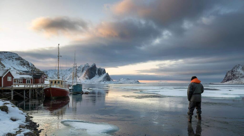
The first hint that something was off came not from a satellite image or a scientific paper, but from a fishing village on the northern coast of Norway. In late January, the harbor should have been choked with sea ice and snowdrifts piling against boat hulls. Instead, rain slapped the water, and a thin fog hung over open, dark waves. Local fishermen told visiting scientists they’d never felt air this mild, this late in the winter. “It feels wrong,” one of them muttered, staring at a thermometer that read just above freezing. He wasn’t alone in that feeling. Across the Arctic, small communities are looking up at gray, unsettled skies, sensing that this year is not like the others. And meteorologists, watching the charts light up on their screens, are quietly sounding the same alarm. Something big is shifting.
Meteorologists are watching the Arctic unravel in real time
On a wall of screens at the European Centre for Medium-Range Weather Forecasts, February looks weird. Not just warmer-than-average weird, but “maps-we’ve-never-seen-before” weird. Swirls of red and orange show heat pushing deep into the Arctic Circle. Sea ice, which should be locking into its winter maximum, is lagging behind, thinner and patchier than models predicted even a few years ago. One senior meteorologist compared it to a roof sagging before a collapse. The structure is still there, just barely, but the strain is starting to show in uncomfortable ways.

Take the Bering and Barents seas, two key Arctic gateways where ice normally hardens like a shield through January. This year, satellite data shows vast stretches of open water where there should already be thick ice. In some regions, sea-ice extent is tracking near or below record lows for this point in winter, echoing what scientists saw in 2016 and 2020, but pushed even further. That missing ice isn’t just a number on a graph. Ships are pushing farther north. Storms are reaching deeper into the polar night. Hunters in northern Canada are finding traditional travel routes unpredictable, riddled with slush and thin ice. Each story adds a human face to a pattern that’s becoming harder to shrug off.

Behind those scenes, the physics is brutally simple. Bright white ice normally reflects sunlight and keeps the Arctic cold. As the ice disappears, darker ocean water absorbs more heat, warming the region faster than the rest of the planet. That extra heat bends the jet stream, the fast river of air that steers weather systems, triggering wild loops that can trap cold air in place or fling it south into North America or Europe. That’s why meteorologists are nervous heading into February. The Arctic is no longer a distant, isolated cold box. It’s more like a wobbling gear in the global climate machine, and when that gear grinds, everyone feels the shake.
 Decathlon’s ‘car’ is the size of a Renault Clio but seats six thanks to 2CV-inspired chairs
What “deteriorating Arctic conditions” really mean for daily life
Meteorologists aren’t just staring at global averages; they’re zooming in on the domino effects. One of the most concrete red flags for February is the unusual warmth building over polar seas and the associated impacts on the polar vortex. When the high-altitude vortex wobbles or weakens, cold air can spill south in sharp blasts. That’s the setup being watched closely this year. The same disrupted Arctic that stays oddly mild up north can help drive brutal cold snaps and heavy snow much farther south. It feels paradoxical, but that’s the pattern showing up more and more in forecast ensembles.
For cities, this can play out as a winter whiplash that no one is really prepared for. Think of a week of damp, eerily mild air in late January followed by a brutal freeze in early February that shatters pipes, disrupts grids, and clogs roads in places that thought the worst of winter was behind them. We’ve all been there, that moment when you pack away your heaviest coat a little too early and regret it with the first icy wind the next morning. On a larger scale, that same miscalculation can hit farmers who bet on an early thaw, or energy planners who underestimate sudden spikes in heating demand. Meteorologists keep repeating the same warning this year: expect the unexpected.
This is why the word “unprecedented” keeps popping up in internal briefings. It’s not just the warmth, or the lack of sea ice, or the strange jet-stream loops. It’s the combination. One Arctic researcher described it as “stacked anomalies” — several unusual trends on top of each other, reinforcing and amplifying the risk of disruptive February weather. The plain truth is that the old patterns people relied on for winter just don’t hold like they used to. And while no single storm or cold outbreak can be blamed on the Arctic alone, the background conditions are clearly loading the dice. That’s what has forecasters on edge as the calendar flips into the heart of winter.
How to live with a winter that no longer behaves like winter
Faced with this new Arctic reality, meteorologists have quietly shifted their advice from “watch and wait” to “adapt and prepare”. One practical method they’re pushing is to think in terms of scenarios instead of a single forecast. That means checking multi-day outlooks, reading the range of possibilities, and planning your week along those lines. If there’s a 40% chance of a deep freeze and snow within ten days, they suggest acting as if that freeze will hit at the worst possible time for you. Top up heating fuel, insulate exposed pipes, keep a basic storm kit sorted. It sounds simple, but it’s the kind of habit that turns a surprise Arctic blast from a crisis into a bad day.
A lot of people still treat winter forecasts like background noise, glancing at an app and moving on. Let’s be honest: nobody really updates their emergency supplies every single day. Meteorologists know this, and they’re trying to bridge the gap with clearer alerts and plain-language bulletins about extreme swings tied to Arctic shifts. They stress not to get hung up on small temperature differences and instead look at patterns: rapid warming, then rapid cooling; unusual rain-on-snow events; heavy, wet snow after a thaw. Those are the setups that can collapse roofs, freeze roads into skating rinks, or spike your energy bill in a single weekend. Being a bit “over-prepared” is suddenly less paranoia and more common sense.

Some forecasters are even getting personal in their messaging, speaking less like distant experts and more like neighbors. One climatologist from Alaska summed it up during a local radio call-in:
“People ask me if this winter is normal, and I tell them: this is our new normal trying to find itself. The Arctic is changing so fast that the weather feels jumpy, unsettled. Planning for that jumpiness is the smartest thing you can do.”
To break the advice down into something you can actually use, think of it as a short checklist:
- Follow regional alerts from national weather services, especially sudden cold snaps linked to polar-vortex shifts.
- Keep one flexible plan for work, school, or travel for each week of February when conditions look unstable.
- Harden your basics: insulation, winter clothing, backup power or charging options.
- Talk with neighbors or family about sharing resources during outages or extreme cold.
- Watch for rain-on-snow events, which can be especially dangerous for roads, roofs, and rural infrastructure.
These small moves don’t fix the Arctic, but they blunt the shock of its new behavior.
A changing Arctic that refuses to stay “far away”
What used to sound like a distant climate headline — sea ice loss, polar amplification, thawing permafrost — has slipped quietly into daily life. A delayed freeze in Siberia reshapes energy markets in Europe. A sagging polar vortex sends Texans scrambling for blankets. Fishermen in Svalbard swap stories with farmers in France about seasons that no longer line up with memory. The Arctic, once framed as remote and untouched, is turning into a kind of global mirror, reflecting back the accumulated heat and habits of the rest of the world in the language of strange winters and jagged forecasts.
Meteorologists warning about “deteriorating Arctic conditions” ahead of February aren’t speaking in abstractions. They’re looking at hard data, yes, but also listening to the crackle of sea ice under unexpected rain, the thawing ground under weather stations that once sat steady on permafrost, the emails from colleagues who’ve had to rewrite their own baseline expectations twice in a decade. For readers far from the polar circle, the question isn’t whether the Arctic matters. It’s how quickly we accept that a destabilized north is already reshaping the rhythms we live by — what we wear, how we heat our homes, when we travel, what farmers plant, which storms we start to fear.
That acceptance doesn’t have to be paralyzing. It can be a nudge to pay closer attention, to swap one lazy scroll through weather apps for a real look at the patterns underneath. To talk with older relatives about the winters they remember and notice how the stories are starting to diverge. The Arctic this February won’t send you a notification when it crosses another invisible line, when a data record quietly breaks in some frozen bay you’ll never visit. But its fingerprints will show up on your doorstep, in the odd warmth, the sudden chill, the storm that wasn’t supposed to be that strong. The question is what we choose to do with that uneasy knowledge.
| Key point | Detail | Value for the reader |
|---|---|---|
| Rapid Arctic warming | Record-low or near-record-low sea ice and unusual winter heat alerts | Helps readers understand why weather feels “off” and more extreme |
| Jet stream disruption | Wavier patterns increase chances of sudden cold blasts and storms in mid-latitudes | Encourages smarter planning for February cold snaps and travel risks |
| Practical adaptation | Scenario-based planning, stronger basics at home, closer attention to alerts | Gives concrete steps to reduce stress and damage during volatile winter events |
FAQ:
- Is this February’s Arctic situation really “unprecedented”?
Scientists are cautious with that word, but many indicators — from sea-ice extent to regional temperatures — are pushing into ranges rarely or never seen in the satellite era, especially when combined.- Does a warmer Arctic mean milder winters where I live?
Not always. A rapidly warming Arctic can disrupt the jet stream and polar vortex, increasing the odds of intense cold snaps and heavy snow in some regions while others get oddly mild, wet winters.- Can one extreme cold event be “caused” by Arctic warming?
No single storm has a single cause, but the background Arctic conditions can load the atmosphere for more frequent or more intense extremes, a bit like stacking the deck in a card game.- What should households actually do differently this winter?
Think ahead in weekly scenarios, keep basic supplies and insulation in better shape, track official warnings, and build in flexibility for work, school, and travel when forecasts show big swings.- Is this the new normal, or will the Arctic stabilize again?
With ongoing global warming, models suggest the Arctic will continue to warm faster than the rest of the planet for decades, meaning more volatility ahead rather than a quick return to the stable winters older generations remember.