The first sign that something was wrong this winter did not come from a weather forecast. It came from small details like the way the air suddenly stung your face one morning after weeks of mild rain. There was the sharp sound of ice breaking in a puddle that had been water just yesterday. There was also the strange feeling that the season was moving backward & forward at the same time.
Across the Northern Hemisphere, people are talking about it. Balconies that were blooming in January, then buried in snow days later. Ski resorts praying for powder, then digging out from dangerous blizzards. Somewhere far above all that, a giant, invisible engine of cold air is beginning to twist and warp in ways that have scientists sitting up straight.

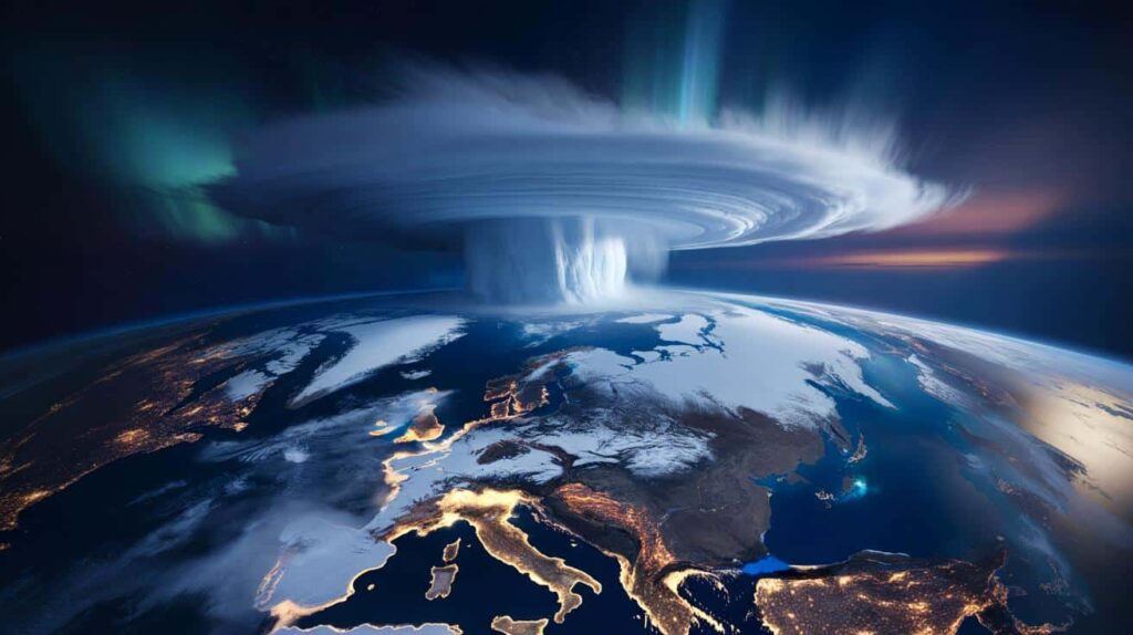
Something rare is forming at the top of the world.
A strange winter, and the silent giant above our heads
Scroll through weather posts right now and it feels like the map is glitching. New York bouncing from hoodie weather to icy wind in a week. Paris flirting with 15°C in January, then dropping into raw, bone-deep chill. Parts of Scandinavia seeing temperatures that would normally belong in Siberia, while chunks of Canada thaw like late March.
Meteorologists have a name for the invisible setup behind this winter mood swing. High above our heads, about 30 kilometers up, the polar vortex — that tight, whirling pool of freezing air that usually spins neatly over the Arctic — is wobbling and stretching. And this time, that wobble looks like it could flip into a full-blown disruption just as February arrives.
Look back at the winters that really stuck in people’s memories and you’ll often find the same pattern. Early 2018, when the “Beast from the East” turned parts of Europe into a frozen postcard. The brutal US cold blasts of 2014 and 2021, when Texas pipes burst and streets turned into ice rinks. In the background each time: a serious polar vortex disturbance high in the stratosphere.
Right now, climate monitoring centers in the US, Europe and Japan are all tracking a similar setup. Models show warming in the stratosphere over Eurasia and the Arctic, a classic red flag that the vortex could weaken, split or shift. That’s the kind of move that tends to unlock the freezer door and let Arctic air spill south in unpredictable bursts.
So what does that actually mean down here, at bus-stop level? When the polar vortex stays strong and compact, the cold mostly stays locked up over the pole. When it weakens or breaks apart, the jet stream — that fast ribbon of air steering storms — can buckle and twist. Those bends let pockets of deep cold plunge into mid-latitudes, while other areas turn weirdly mild.
Atmospheric scientists are careful with their words, but they’re unusually aligned on one point: **February is shaping up as a high-risk month for extreme swings**. Not guaranteed snowmaggedon, not automatic blizzards for everyone. But a heightened chance of sharp, prolonged cold snaps, heavy snow bands and stormy contrasts in North America, Europe and parts of Asia. The dice are being loaded right now, quietly, halfway to space.
How a wobbling polar vortex can land on your doorstep
Think of the polar vortex as a spinning top on a table. When it’s centered and fast, it stays in its lane. When it slows or gets nudged, it starts to wander, tilt, even fracture. That’s essentially what happens up there when sudden stratospheric warming events kick in — bursts of heat from below disrupt the vortex and send ripples down through the atmosphere.
➡️ Bird experts expose the winter fruit trick that turns robins into garden addicts
➡️ Underfloor heating is now just a memory: everyone is choosing this alternative that saves money and heats better
➡️ 7 grandma-approved tricks to clean a light switch and make it look brand new
Meteorologists are issuing warnings about an Arctic disruption happening in early February that points to a biological tipping point for animals. Scientists are expressing serious alarm about this development. The Arctic region is experiencing unusual atmospheric changes that could have far-reaching consequences for wildlife populations. These disruptions are not just weather events but indicators of deeper environmental shifts that affect animal behavior and survival patterns. Experts studying these phenomena note that the timing of this disruption is particularly concerning. Early February represents a critical period for many Arctic species as they navigate seasonal transitions and prepare for breeding cycles. When atmospheric conditions change dramatically during this window, it can throw off biological rhythms that animals have relied on for thousands of years. The scientific community is paying close attention because similar disruptions in the past have preceded significant changes in animal populations. Species that depend on specific temperature ranges & ice conditions are especially vulnerable. Marine mammals like seals & polar bears face challenges when ice formations break up earlier than expected or form later than usual. Bird migration patterns are also at risk. Many species use environmental cues to time their journeys and when those signals become unreliable, it can lead to mismatches between when birds arrive at breeding grounds & when food sources are available. Researchers emphasize that this is not an isolated incident but part of a broader pattern of Arctic instability. The region is warming faster than other parts of the planet, and these meteorological disruptions are becoming more frequent & intense. The biological tipping point that scientists reference occurs when ecosystems can no longer adapt to the pace of change. Animals may not be able to adjust their behaviors quickly enough to survive in rapidly shifting conditions. This could lead to population declines & potentially permanent changes to Arctic food webs.
➡️ A groundbreaking new strategy makes cancer cells visible, allowing the immune system to detect and attack them more effectively
➡️ These everyday signs could warn of Alzheimer’s disease years before diagnosis
➡️ Eclipse of the century: 6 minutes of darkness: when it will happen and where to watch it
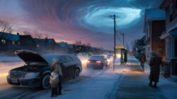 Polar vortex forecast sparks alarm as experts quietly admit conditions could turn extreme fast
➡️ Discovered in Spain in 1994, the “Excalibur” sword may have Islamic origins
Those ripples don’t arrive as neat, global changes. They show up as strange local weather: a week of relentless east winds in Britain, a lobe of Arctic air parked over the Midwest, an endless chain of storms hammering Central Europe. One city shivers under record lows while another, just a few hundred miles away, watches rain wash away any hint of winter. This is why forecasts suddenly sound a bit less confident and a lot more conditional.
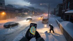
Take February 2021 in the US as an example. Atmospheric scientists had been warning for weeks that the stratospheric polar vortex was breaking down. Most people never heard those early alerts. What they experienced was the result: a severe cold wave that reached deep into Texas. Millions lost power and homes that were never built for extended freezing temperatures suffered from burst pipes and frozen infrastructure.
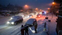
In Europe, older residents still talk about February–March 2018 the way previous generations talked about famous blizzards. The polar vortex had been rattled, and suddenly Siberian air poured westward. Trains froze on tracks. Supermarket shelves thinned. Daily routines shrank to “Can I safely get to work?” and “Do I have enough food at home?” One shift in a high-altitude wind pattern turned into a very physical reality at kitchen-window level.
This winter’s developing pattern is not an exact copy of those years but the similarities are present. Multiple climate centers are now indicating a likely weakening of the vortex as we move into February. Several models suggest that the cold weather may last longer this time rather than being just a brief drop in temperature. This could result in extended cold periods across parts of Europe and North America while other regions experience unusual warmth & rain.
We all experienced that moment of looking outside and thinking the weather seems unusual for the season. Scientists are examining this same issue from a technical perspective. Increasing greenhouse gases are heating the lower atmosphere and causing changes to storm patterns and snow coverage. These changes may also affect how energy transfers upward into the stratosphere. Scientists are not attributing every cold spell to climate change. However they no longer view the polar vortex as a separate system that operates independently from other atmospheric processes. they’ve
So what can you actually do before February flips?
It’s easy to hear “polar vortex disruption” and tune out, like it’s just another scary headline. The more helpful move is simpler: read the forecast one level deeper than usual over the next few weeks. Look not just at tomorrow’s temperature, but at the 7–10 day trend and at how confident forecasters seem. Words like “blocked pattern”, “Arctic outbreak” or “high uncertainty” are quiet clues that big-picture dynamics are in play.
Then think in terms of layers, not panic. A backup heat source if your area is prone to outages. Extra blankets where kids or older relatives sleep. A simple stash of candles, batteries and shelf-stable food, not a bunker. *Planning for a rough week of weather isn’t doom-thinking; it’s just a modern version of what past generations did instinctively before winter.*
Where people often get caught out is by trusting the weather of the last few years too much. A run of mild winters lulls you into thinking snow is over for your city, that your thin jacket is enough, that your home “usually” stays warm. Then one sharp cold blast comes through and exposes every weak point at once. Frozen pipes. Slippery commutes. Schools scrambling to close or stay open with too little notice.
Let’s be honest: nobody really does this every single day. We don’t wake up thinking about Arctic oscillations and gas line insulation. But if your region has been mentioned in any of the long-range outlooks connected to this polar vortex shift, this is your nudge. Check your winter tires. Learn where your water shutoff valve is. Talk, very practically, with the people you share a home with: “If we lost power for two days during a cold snap, what would we actually do?”
“Severe winter weather is not a rare occurrence anymore” says Dr. Laura Schmidt, a climate dynamics researcher in Berlin. “These events have become part of a new pattern of variability. The stratosphere provides us with early warnings. The question is whether we pay attention to them at ground level.”
- Stock a small “cold snap kit”
A box with spare blankets, hand warmers, a flashlight, batteries, basic meds and a few days of simple food. One place, easy to grab. - Audit the cold spots in your home
Walk around on a windy evening. Feel for drafts near windows, doors and outlets. Even cheap weatherstripping can blunt the worst chills. - Update your mental map of risk
Check if your area has faced power cuts, burst mains or transport shutdowns in past cold waves. **History is often a better guide than a single app forecast.** - Plan for remote work or school
If your job or kids’ school can go online, have a plan written down. Devices charged, backup hotspot, printed key contacts. - Look out for your quiet neighbors
Elderly people, single parents, new arrivals in your building — they’re often the first to struggle in weather extremes and the last to ask.
A winter that’s about more than just cold
There’s a strange tension in this story. On one hand, a polar vortex shift sounds technical and distant, a phrase that belongs in lab reports and satellite briefings. On the other hand, its fingerprints show up in the most ordinary moments: the bus that never arrives, the heating bill that hurts, the shiver you weren’t expecting when you stepped outside in what was supposed to be a “mild” winter.
This February could become one of those months that people talk about years from now. They might say remember that winter when the weather changed from feeling like spring to freezing cold in just one night. Scientists around the world are working hard to understand how global warming can still cause sudden waves of extremely cold Arctic air. The explanation behind it keeps getting better as research continues. But for people going through it the reality stays straightforward. Everyone just focuses on adjusting to the conditions and looking after each other while figuring out practical solutions as they go.
Maybe that is the real change taking place right now. It is not just happening in the stratosphere but also in how we understand seasons. We are starting to see them less as predictable schedules and more as shifting & unpredictable forces that we need to learn to interpret. Your weather forecast for the coming weeks tells one part of the story. The other part is the one you will remember and share later. It includes where you were during those days & who you reached out to. It also includes how your street appeared when the sky finally settled on what kind of winter it would bring.
| Key point | Detail | Value for the reader |
|---|---|---|
| Polar vortex shift | Stratospheric warming is weakening and displacing Arctic cold air | Helps you understand why February may bring abrupt, intense changes |
| Local impacts | Higher odds of cold snaps, heavy snow bands and stormy contrasts | Signals when to watch forecasts closely and adapt daily plans |
| Practical readiness | Small steps: cold snap kit, home draft checks, risk conversations | Reduces stress, costs and disruption when extreme weather hits |
FAQ:
- Is the polar vortex “coming for us” this February?Not exactly. The polar vortex is always there, spinning over the Arctic. What experts are warning about is a likely disruption that makes cold outbreaks toward mid-latitudes more probable, not guaranteed for every region.
- Does a polar vortex event mean nonstop snow?No. Some areas may see heavy, persistent snow, others just dry but bitter cold, and some may actually turn milder. It depends on how the jet stream bends over your region.
- Is this because of climate change?Scientists are still debating the exact link. There’s growing evidence that a warming Arctic and changing snow patterns can influence the polar vortex, but not every cold wave is directly “caused” by climate change.
- How far ahead can these events be predicted?Signals in the stratosphere can be spotted one to three weeks in advance. Translating those into precise local weather is harder, so forecasts often talk in terms of increased risk rather than exact snowfall totals.
- What’s the one thing I should do before February?Take ten minutes to check your home and routine for a 2–3 day cold disruption: warm clothing, basic supplies, a way to get updates and a simple plan with family or housemates. That small effort pays off in peace of mind when the next cold blast arrives.