The alert appeared on my screen right after breakfast. It was sandwiched between a video of a raccoon stealing cat food and a sale on winter boots. The headline warned that a major polar vortex disruption was developing. It said the February magnitude was almost unheard of. Outside the street looked perfectly normal. A few kids were walking to school with their breath hanging in the air. Nothing looked apocalyptic about it.
Inside the weather labs, though, the mood is very different. High above our heads, 30 kilometers up, the atmosphere is twisting, stretching, and breaking in ways that simply don’t show up in daily life yet.
You do not feel a polar vortex when you open your window. The polar vortex is not something that directly touches your skin or rushes into your home. It exists high above the Earth in the stratosphere where the air is thin and the temperatures are extremely cold. This massive circulation of winds spins around the Arctic region during winter months & acts like a container that keeps frigid air locked near the North Pole. When meteorologists talk about the polar vortex affecting weather it means the system has weakened or shifted from its usual position. This allows cold Arctic air to spill southward into regions that normally experience milder temperatures. The cold air mass that eventually reaches your area has traveled thousands of miles and mixed with other air masses along the way. What you actually feel when you open your window during a cold snap is the result of that displaced Arctic air. By the time it arrives at your location it has been modified by its journey across the continent. The air picks up moisture and interacts with warmer air masses which changes its characteristics from what existed in the upper atmosphere. The term polar vortex has become popular in weather reports and news coverage but it often gets misused. People sometimes use it as another way to describe any period of very cold weather. However the polar vortex itself remains in the upper atmosphere while only its effects reach ground level. Understanding this distinction helps clarify why scientists differentiate between the polar vortex as a meteorological phenomenon & the cold weather events that result from its disruption. The vortex is always present during winter but only becomes newsworthy when it weakens enough to allow significant amounts of Arctic air to move into populated areas.

But you will feel what happens next.
 A polar vortex disruption is on the way, and its magnitude is almost unheard of in February
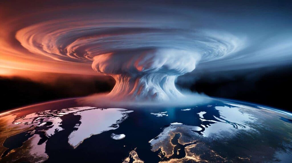
A quiet monster spinning above our heads
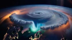
Think of the polar vortex as a giant, invisible hurricane wrapped around the North Pole. It’s not a single storm, not something you see on the horizon. It’s a swirling ring of icy air in the stratosphere, circling at jet-plane height and beyond, locking in the cold like a lid on a freezer.
Most winters, it hums along in the background, strong and stable. The Arctic stays brutally cold, and the rest of us get a relatively predictable mix of chilly days and warm breaks.
This winter, that “lid” is cracking open in an extraordinary way.
Over the past few days, meteorologists from the U.S., Europe, and Japan have been watching their charts light up. Stratospheric temperatures over the pole are spiking by 40–50°C above normal in places, an extreme signal that usually shows up only in case studies and old textbooks.
One major research team said that the current disruption is one of the most powerful February events in recent history. It matches or possibly exceeds the famous episodes that occurred in 2018 and 2009. Those winters brought unexpected blizzards to areas where people believed spring would arrive soon.
On social media, weather accounts are already posting animations of the polar vortex stretching, then snapping like a rubber band. The comments below are a mix of nerdy excitement and quiet dread.
➡️ Divisive opinions about “cumulant” seniors: why more retirees are forced back to work instead of enjoying their hard-earned pensions
➡️ Nobody Realizes It, But France Has Quietly Beaten Britain To A 305‑Year World Record At Sea
➡️ If you feel mentally sharp but emotionally foggy, psychology explains the disconnect
# Drying Laundry in Winter Has a Hidden Rule: Why Some Homeowners Swear by Frost & Others Call It Pointless Superstition
Winter laundry drying divides people into two camps. Some households hang their washing outside even when temperatures drop below freezing. Others think this practice makes no sense and prefer indoor drying methods instead. The debate centers on whether frozen laundry actually dries or just becomes a stiff icy mess. People who support outdoor winter drying claim their clothes come back fresh & completely dry. Skeptics argue that freezing temperatures prevent proper evaporation and waste time. The science behind winter drying explains both viewpoints. When wet laundry freezes outside it undergoes a process called sublimation. This means ice crystals transform directly into water vapor without becoming liquid first. The process works best on cold dry days with low humidity and some wind movement. Supporters of frost drying point out several benefits. Frozen laundry often smells fresher than items dried indoors during winter. The cold kills bacteria and eliminates musty odors that develop in poorly ventilated spaces. Sunlight even on cold days helps bleach whites naturally and adds a crisp outdoor scent. Energy savings also matter to outdoor drying enthusiasts. Hanging laundry outside costs nothing compared to running electric dryers or heating indoor drying racks. For households watching utility bills this difference adds up over an entire winter season. Critics raise valid concerns about the method. Sublimation takes much longer than regular evaporation. Laundry might stay outside for days before drying completely. Heavy items like towels and jeans freeze solid & need additional indoor time to finish drying. The process demands patience that busy families may not have. Weather conditions determine success or failure. Humid winter days prevent sublimation from working effectively. Clothes might freeze but retain moisture that only releases once brought inside. Snow or freezing rain obviously ruins the entire effort. The practical middle ground combines both approaches. Many experienced winter washers start laundry outside on suitable days. Once sublimation removes most moisture they bring items inside to finish drying. This method captures the freshness benefits while ensuring clothes dry completely. Fabric type influences results significantly. Thin cotton items and synthetic materials dry faster through sublimation. Thick natural fibers hold more water & struggle in freezing conditions. Sorting laundry by weight and material improves outdoor winter drying success. Regional climate plays a major role in whether this technique works. Areas with dry cold winters and frequent sunshine see better results. Regions with damp cloudy winters find outdoor drying frustrating & ineffective. The hidden rule that resolves this debate is simple. Winter outdoor drying works under specific conditions but fails as a universal solution. Success requires cold temperatures combined with low humidity & air movement. Without these factors the practice becomes more trouble than benefit. Personal preference and household circumstances matter just as much as science. People with limited indoor space may accept longer drying times for the space savings. Those with ample indoor drying areas might skip the outdoor hassle entirely. Neither camp holds the complete truth. Winter laundry drying outside succeeds for some households & disappoints others based on local weather & individual priorities. Understanding the sublimation process helps people make informed choices rather than following tradition blindly. The practice continues because it delivers real advantages when conditions align properly. Fresh scent & energy savings appeal to environmentally conscious households. The method fails when weather refuses to cooperate or when convenience outweighs other considerations. Modern alternatives like heat pump dryers and dehumidifier drying rooms offer middle options. These technologies provide energy efficiency without depending on outdoor conditions. Still many people prefer traditional methods that connect them to seasonal rhythms and natural processes. The winter laundry debate ultimately reflects different values about time & resources and connection to weather patterns. Both approaches work within their proper contexts. The key lies in matching method to circumstances rather than declaring one side universally correct.
➡️ Stop washing your hair this often dermatologist warns we have been doing it all wrong
➡️ Light will disappear for minutes experts warn an extraordinary solar eclipse is officially approaching
➡️ China tests the unthinkable with a centrifuge that compresses time and space: the figures are staggering
➡️ Bad news for coffee lovers as hepatologist lists the 6 main symptoms of fatty liver “I only drink a few cups a day” – a story that divides opinion
So what does “disruption” actually mean in real life? In simple terms, the polar vortex is being shoved out of its usual place by powerful waves of energy rising from lower in the atmosphere. When that happens, pieces of that icy air can spill south.
Sometimes it slams North America. Sometimes Europe takes the hit. Sometimes the cold fans out in lobes, producing weird see-saw patterns of deep freezes and unexpected warmth.
The catch is timing. A major stratospheric disruption like this one often takes 1–3 weeks to filter down and reshape the weather we actually feel. Right now, we’re watching the fuse burn.
Why this February event has experts on edge
When scientists say a February disruption of this size is “almost unheard of,” they’re not exaggerating for clicks. Stratospheric warming events do happen in winter, but the strongest ones usually peak earlier in the season. February, historically, is more about the slow fade-out of deep winter patterns than atmosphere-shaking surprises.

This time, the timing and magnitude are pairing up in an unnerving way. The polar vortex isn’t just wobbling; parts of it are flipping and reversing high-altitude winds, the tell-tale sign that the whole system is being rearranged.
For forecasters, this is like having the chessboard suddenly spin around at move 20.
Take the 2018 event as a benchmark. A major polar vortex breakdown in February of that year sent frigid Arctic air blasting into Europe. London saw snow and chaos. Parts of the UK recorded their coldest late-winter spell in years.
In the U.S., the same disruption helped flip the pattern into a cold March for some regions, even as others basked in a strange warmth. Commuters trudged through late-season slush in cities that had already mentally moved on to spring jackets and tulips.
Now, several modeling centers say the current disruption is at least in the same league, possibly stronger. That’s the kind of comparison that grabs the attention of anyone who lived through “the Beast from the East” or those bone-deep cold snaps.
So why the superlatives from experts this time? Partly because of the data. Reanalyses stretching back to the late 1970s suggest that events of this strength, this late in winter, are extremely rare in the satellite era.
And partly because the background climate has shifted. With the planet warmer overall, the contrast between Arctic cold and mid-latitude warmth is changing. That’s stirring a fierce debate in the climate science world about whether a weakening, wobblier polar vortex is becoming more likely.
Nobody can predict the future with complete accuracy. However when experienced atmospheric scientists start using words like exceptional and near unprecedented it makes sense to pay attention. The truth is that weather forecasting remains an imperfect science. Even the most advanced computer models and satellite technology cannot account for every variable that influences our climate systems. Scientists work with probabilities rather than certainties when they issue their predictions. That said there is something significant about the language experts choose when they communicate their findings. These are professionals who have spent years studying atmospheric patterns & weather phenomena. They understand the historical context of what they observe. When they describe current conditions as exceptional or near unprecedented they are drawing on decades of data & research. The term exceptional indicates that what they are seeing falls well outside normal parameters. It suggests conditions that occur rarely in the historical record. Near unprecedented means we have seen something similar before but only once or twice in the entire period we have been keeping detailed records. These descriptions serve as important signals. They tell us that current atmospheric conditions differ substantially from typical patterns. They suggest that the weather events we might experience could be more severe or unusual than what we normally encounter. Scientists choose their words carefully especially when communicating with the public. They know that alarmist language can cause unnecessary panic while understated warnings might not prompt adequate preparation. When they use strong descriptive terms it reflects genuine concern based on observable data. The challenge for most people is knowing how to respond to these warnings. We live busy lives filled with constant information & competing demands for our attention. It becomes easy to dismiss warnings as exaggeration or to assume someone else will handle whatever problems might arise. But weather events affect everyone. Extreme conditions can disrupt transportation systems damage infrastructure threaten agriculture & endanger lives. Being informed about potential risks allows individuals & communities to prepare appropriately. Preparation does not require panic. It simply means taking reasonable precautions based on the best available information. This might include checking emergency supplies staying informed about local conditions or having a plan for how to respond if severe weather occurs. The atmospheric scientists issuing these warnings have no incentive to exaggerate. Their professional reputations depend on accuracy and credibility. They issue strong warnings because the data they analyze indicates genuine cause for concern.
What this could mean for your weather in the next few weeks
So, practically, what do you do with a story about winds 30 kilometers up? The first step is boring but powerful: pay closer attention to medium-range forecasts (7–14 days) than you usually would in February. Patterns are likely to reshuffle fast.
If you live in the northern U.S., Canada, or much of Europe, treat late February and early March like “weather wildcard” weeks. That might mean a sudden cold plunge when you’d usually expect soft, muddy thaw. Or intense temperature swings that feel more like April mood swings than classic winter.
Think of it as planning your life with an extra plot twist in mind.
We’ve all been there, that moment when you’ve packed away your heavy coat because the sun finally felt kind for two days in a row. This season, that move could backfire. One concrete gesture: delay your mental “end of winter” by at least two weeks, especially if your local meteorological service starts flagging a pattern change.
Don’t panic-buy or spiral. Just shift your mindset from “winter is over” to “winter is recalculating.” That’s a quieter form of resilience, and it matters more than stocking up on three extra loaves of bread.
*The atmosphere owes us no sense of timing, even if the calendar says March is close.*
Experts are trying to strike a careful tone. They know the headlines can jump straight from “polar vortex disruption” to “Snowmageddon incoming,” skipping all nuance in between.
A senior climatologist explained to me this week that stratospheric warmings do not promise extreme cold weather in your area. However they do increase the chances of strange weather patterns developing. He compared it to changing the probability rather than determining the exact outcome.
You can do more than just check your local forecast. Keep a simple mental checklist ready:
- Layered wardrobe still accessible, not buried in storage
- Home basics checked: heating, insulation quirks, drafty windows
- Flexible plans for travel or outdoor events in late February
- A realistic view of snow and ice risk, even if you just had a warm spell
- A bit of curiosity about what’s happening above, not just outside your door
The bigger story: a restless sky and a changing climate
What is happening above the Arctic right now goes beyond an interesting science story. It connects to a deeper worry that many people experience when the seasons no longer act the way they did in childhood memories. Some years winter hardly appears at all. Other years it arrives late and lingers too long. The changes feel unpredictable and unsettling. People notice that familiar weather patterns have shifted in ways that seem wrong. The timing of snowfall has become irregular. Temperature swings occur more frequently than before. These observations match what scientists have been documenting for years. The Arctic region plays a crucial role in regulating weather patterns across the entire planet. When conditions there change dramatically it affects weather systems far beyond the polar region. Warm air masses now penetrate areas that used to remain consistently cold. Ice coverage has diminished significantly over recent decades. These transformations alter the atmospheric conditions that influence weather in populated areas. The jet stream provides a clear example of these changes. This band of strong winds flows high in the atmosphere & helps direct weather systems. When Arctic temperatures rise the jet stream becomes less stable. It develops larger waves and moves more slowly. This allows weather patterns to persist longer in one location. A cold snap might settle over a region for weeks instead of days. A warm period might extend well beyond its normal duration. People experience these changes in their daily lives. Farmers struggle with unpredictable growing seasons. Cities face infrastructure problems when weather exceeds design specifications. Insurance companies adjust their risk models. Energy providers deal with unusual demand patterns. The effects ripple through society in countless ways. The scientific data supports what people observe in their communities. Temperature records show clear warming trends in Arctic regions. Satellite measurements reveal declining ice extent. Ocean temperatures have risen in polar waters. These changes are not subtle or debatable. They represent measurable shifts in physical conditions. Understanding these changes matters for practical reasons. Better predictions help communities prepare for extreme weather. Improved models allow for more effective resource planning. Knowledge of Arctic conditions enables more accurate long-range forecasts. The science provides tools for adaptation even as the changes continue.
Scientists are still arguing over exactly how a warming planet is reshaping the polar vortex. Some studies tie weaker, more disturbed vortices to shrinking Arctic sea ice and amplified warming at the pole. Others urge caution, warning that the pattern may be more complex and cyclical than a simple cause-and-effect headline.
Either way, we’re entering an era where “almost unheard of in modern records” might become a phrase we hear more often.
| Key point | Detail | Value for the reader |
|---|---|---|
| Major February disruption | Current polar vortex event ranks among the strongest late-winter cases in modern data | Helps you understand why forecasters sound unusually alert right now |
| Delayed surface impact | 1–3 week lag between stratospheric disruption and potential pattern shifts at ground level | Gives you a realistic window to watch for changes instead of reacting overnight |
| Local uncertainty | Event raises odds of unusual patterns, but not guaranteed cold or snow in every region | Encourages smart vigilance, not panic, as you follow local forecasts |
FAQ:
- Will this polar vortex disruption definitely bring extreme cold where I live?
No. It increases the chance of unusual weather patterns, including cold outbreaks in some regions, but it doesn’t guarantee a deep freeze for every city. Local forecasts are still your best guide.- When could I start noticing effects from this event?
Most major polar vortex disruptions take roughly 10–20 days to influence surface weather. That points to late February and early March as the key watch period.- Is this linked to climate change?
Scientists are still debating the strength of the connection. Some research suggests a warming Arctic may make the vortex more prone to disruption, while other studies are more cautious. The background climate is warmer either way.- Could this mean heavier snow later in the season?
In some areas, yes, the odds of late-season snow or sharper cold snaps can rise after events like this. In other regions, it might show up as blocking patterns, with persistent warmth or dryness. It’s not a one-size-fits-all outcome.- Should I change my plans because of this?
You don’t need to cancel life. Just stay a bit more flexible with travel and outdoor events over the next few weeks, keep winter gear handy, and follow updated forecasts from trusted local sources.